Posts

Showing posts from November, 2005

Secondary school attendance in Nigeria

Image
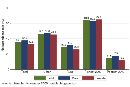
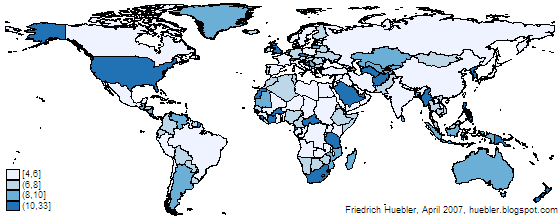
Nigeria is the country with the largest population in Africa, estimated at 130 million in 2005. The most recent education data for Nigeria was collected in a Demographic and Health Survey (DHS) in 2003. 60.1% of all children of primary school age were attending primary school at the time of the survey. Far fewer children continue their education at the secondary level. The official secondary school age in Nigeria is 12 to 17 years and 35.1% of the children in this age group were in secondary school according to the DHS. For boys the secondary school net attendance rate (NAR) was 37.5% and for girls it was 32.6%. Secondary school net attendance rate, Nigeria 2003 Data source: Nigeria 2003 DHS. The attendance rate is strongly linked to household wealth and area of residence. 63.8% of children from the richest 20% of all households were in secondary school, compared to only 14.6% of children from the poorest 20% of all households. The secondary school NAR in urban areas was 46.3% and in ...

Guide to creating maps with Stata (archived version)

Image
As of 31 August 2012, this document is no longer maintained and has been replaced by a new guide to creating maps with Stata . The archived version of the guide is only of interest to users of Stata 8, who will find instructions below. All users of Stata 9 or later versions are advised to follow the new guide . Please change your links to the new guide: http://huebler.blogspot.ca/2012/08/stata-maps.html . The graphs and maps on this site are created with the Stata statistical package. This article describes how to make maps like those showing Millennium Development Goal regions and UNICEF regions in Stata from a shapefile. Shapefiles store geographic features and related information and were developed by ESRI for its ArcGIS line of software. The shapefile format is used by many other programs and maps in this format can be downloaded from various sites on the Internet. Another common map format is the MapInfo Interchange Format for use with the MapInfo software. Shapefile data is...